


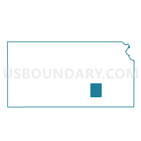
Murdock Township Voting District, Butler County, Kansas
About
Outline

Summary
| Unique Area Identifier | 584119 |
| Name | Murdock Township Voting District |
| County | Butler County |
| State | Kansas |
| Area (square miles) | 36.29 |
| Land Area (square miles) | 36.29 |
| Water Area (square miles) | 0.00 |
| % of Land Area | 100.00 |
| % of Water Area | 0.00 |
| Latitude of the Internal Point | 37.86889330 |
| Longtitude of the Internal Point | -97.09730390 |
Maps


Graphs
Select a template below for downloading or customizing gragh for Murdock Township Voting District, Butler County, Kansas


Neighbors
Neighoring Voting District (by Name) Neighboring Voting District on the Map
- Benton Township/City Voting District, Butler County, KS
- Fairview Township Voting District, Butler County, KS
- Lincoln Voting District, Sedgwick County, KS
- Plum Grove Township/Potwin Voting District, Butler County, KS
- Richland Township Voting District, Harvey County, KS
- Towanda Township/City Voting District, Butler County, KS
- Whitewater/Milton Township Voting District, Butler County, KS
Top 10 Neighboring County Subdivision (by Population) Neighboring County Subdivision on the Map
- Towanda township, Butler County, KS (2,668)
- Benton township, Butler County, KS (2,278)
- Milton township, Butler County, KS (1,153)
- Plum Grove township, Butler County, KS (660)
- Lincoln township, Sedgwick County, KS (523)
- Fairview township, Butler County, KS (519)
- Murdock township, Butler County, KS (402)
- Richland township, Harvey County, KS (367)
Top 10 Neighboring Unified School District (by Population) Neighboring Unified School District on the Map
- Circle Unified School District 375, KS (9,071)
- Remington-Whitewater Unified School District 206, KS (3,659)
Top 10 Neighboring State Legislative District Lower Chamber (by Population) Neighboring State Legislative District Lower Chamber on the Map
- State House District 99, KS (34,751)
- State House District 75, KS (21,740)
- State House District 74, KS (20,785)
Top 10 Neighboring State Legislative District Upper Chamber (by Population) Neighboring State Legislative District Upper Chamber on the Map
Top 10 Neighboring 111th Congressional District (by Population) Neighboring 111th Congressional District on the Map
Top 10 Neighboring Census Tract (by Population) Neighboring Census Tract on the Map
- Census Tract 206, Butler County, KS (7,687)
- Census Tract 306, Harvey County, KS (7,256)
- Census Tract 101.16, Sedgwick County, KS (2,200)